It’s time to dream of summer bike tours, and maybe even start planning routes. If you’ve been following the progress of the MoPac gap and it’s importance in the Great American Rail Trail, you may have wondered about some of the other trails in the region and how they connect. You know about the Homestead trail to Beatrice which continues as the Chief Standing Bear, then goes on to Marysville as the Blue River Trail. You may be familiar with the Wabash Trace from Council Bluffs to Missouri. Also there’s the Steamboat Trace from Brownville almost to Nebraska City. But did you know they can be linked together into a large regional loop? If you like to tour, or wonder how it could all fit together, routes have been created to facilitate your wanderlust without wandering too far away. It’s called the Quad State Trail System. From the guide: “Now, how can we connect from the Rock Island Trail to St Joseph MO, Lincoln NE, Omaha NE–using as many existing trails as possible, and low-traffic, low-stress paved connector routes to fill the gaps?” You can click on each segment to explore it in detail, or go to the bottom and click on ‘show all on map’ to see how it fits together.
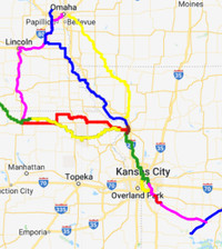
The connections are not all trails; some parts are gravel, most are pavement. From Marysville the map takes you on the historic Pony Express route to St. Joseph, but If you want to go a little farther afield, you can head south from where the loop passes through St. Joseph to the Kansas City area. There, new segments of their Rock Island Trail have been finished. Eventually, you can connect to the Katy Trail and ride on to St. Louis. As trail connections continue to be created, more bicycle tourism and infrastructure is bound to follow.
Ride with GPS and the Missouri Bicycle & Pedestrian Federation, the sister organization to Bike Walk Nebraska, has created these routes so you don’t have to. Do be a little careful of some draft segments, though. Their route using the Steamboat trace north to Omaha shows our (preferred) segment of the MoPac gap, 322 St. between Church and Mynard Rds. which was not chosen as the final gap route and is currently impassable due to past flooding.