Well it wasn’t the ride I set out to do, but it was an interesting ride to end up having done. I don’t have problems navigating Lancaster or Cass counties. My rides in Otoe, Nemaha, Johnson, Sarpy, other counties, and even Iowa have been navigationally uneventful. Odin’s Revenge is a gravel race in the Gothenburg area consisting of a short course and a long course of about 180 miles. I did it last year year, so I knew pretty well what to expect, though the course changes from year to year. So what happened this time? Well, in part I was a victim of my past success. First though, you out there that stick to the trails have little to worry about if you use a map, available at most fine bike shops or on line. What I’m talking about here is when we don’t have a map or a digital file of a map. I had intended to use the gps on my phone, in airplane mode, and cue sheets to keep me on track. Cue sheets provide a list of turns, road names, markers and directions to follow.
Last year I lost my cue sheets early on along with part of my supplies when I slipped into a deep rut and I didn’t notice they were gone right away. Not being in the lead has it’s perks. I was able to read the tire tracks of those ahead of me after we spread out and I couldn’t see anyone up ahead. I did this successfully until the 100 mile checkpoint in Curtis where we received the second set to finish the course. Since then I’ve continued the practice at times and have found it to be effective when the road surface allows. My problem this time is that my gps didn’t pick up until about 40 miles into the ride, throwing all the corresponding mileage counts off. The back up cyclo computer I have tried to use before and this time brought a back up power supply for became full and wouldn’t record more data. Still, I should have been checking my cue sheet better and not been relying so much on the tracks this time. Soon after leaving checkpoint two I saw a large number of very obvious fresh tire tacks turning right, and without consulting my cue sheet, I followed suit. I had already done a fairly minor course deviation coming up on checkpoint one, so you wouldn’t think I’d fall for that again, but I did. I didn’t know that what I was seeing was the small overlap between the short course and the long course. I ended up following their course back in reverse along with Mark from Louisville KY who had lost his cue sheet. Arriving at the end of the first loop I had ridden nearly 15 extra miles and wasn’t entirely sure I wanted to start the second half, but after resting and re-fueling that’s what I did, nudged by Scott Redd of Omaha.
It would have been a pity to waste the beautiful weather I had fretted about, and my knees were feeling fine. I was feeling so good that after a while I left my dependable friend Scott behind and was soon once again on my own. As it turns out my navigational problems were not behind me yet, and I misinterpreted a turn and some tracks and added some steep and powdery miles before I realized I was on the wrong road yet again. When I finally rode into checkpoint four there was Scott enjoying a beverage and the good company of the fine volunteers. After a while we took off and Scott, having had no navigational issues up until that point, apparently began to come under my bad influence even though I was not directing and we started to get lost as the sun was setting. Last year I had finished just after sunset an it was obvious that wasn’t going to happen this year.
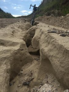
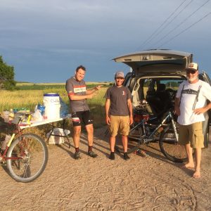
After having to consult a map with a local farmer, we headed back up the steep descent we had just come down and found the sketchiest part of the whole course, the tall grass double track, though that’s probably overstating just how much of it was actually visible. We made it out of there as the last glimmer of light left the horizon, but with our lights we were able to see the geyser of sealant erupting from a puncture in my tubeless tire. After that was under control, the rest of the course was uneventful. It had gotten late so eventually the amazingly generous and thorough race organizers, Chad and Merrie Quigley came looking for us, but by that time we were not far from the end.
All in all it was a great event, and I had a lot of fun. The scenery is spectacular and you see things when you are that far off the beaten track you wouldn’t see anywhere else. I even got in a full 200 miles, something I hadn’t done before, and rode with some great people. So what will I change for next time? It starts with a fully functioning gps…