So you want to use your bike to get somewhere in Lincoln – but how?
The route you’d take in your car is rarely the best bike route. When you start thinking like a cyclist, you’ll find that you develop a hierarchy of path/street types in your mind that guides you as you look at a map. From most (green) to least (red) comfortable, here’s mine:
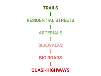
Yours may be completely different, and that’s perfectly fine. It will be based entirely on your comfort level and your experiences. I’ll discuss mine, in case it gives you a starting point for thinking about route selection – but five cyclists in a room will have five different opinions on this subject, so disagreement is likely. Just get out and ride, and experiment!
TRAILS
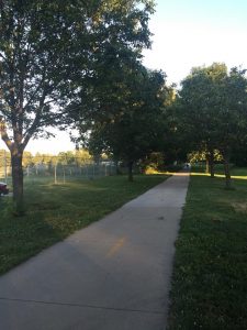
There are 131 miles of trails – and counting! – in Lincoln. We’re fortunate to have a trail system that was listed among the Great Public Spaces in the American Planning Association’s Great Places in America. Chances are pretty good that, wherever you are in Lincoln, you’re not too far from a trail. When you’re lucky enough to be able to use a trail for all or at least a good part of your route, you can enjoy quiet paths mostly separated from vehicle traffic. These are my first choice – and I bought a condo right between two major trails to increase the likelihood of a trail getting me where I need to go.
Pros:
- Largely car-free (except for intersections)
- Can sometimes be a more direct, as-the-crow-flies path
- Scenic
Cons:
- More dangerous than they appear! Remember to keep right, call out when you pass people, and be alert.
RESIDENTIAL STREETS
Trails don’t quite go everywhere, but most of the time, I can get where I’m going with a combination of trails and residential streets. In the older parts of town, which are laid out on a grid system, you can often find a quiet residential street running parallel to the arterial street you’d take in your car. You can also check a Great Plains Trails Network bike map to find Lincoln’s network of on-street bike routes.

Pros:
- Most residential streets are quiet and pleasant.
- Speed limits of 25 mph mean that even when you encounter cars, they shouldn’t be going too much faster than you.
- In the parts of the city laid out on a grid system, navigating residential streets is easy. It’s not too bad elsewhere, either, with some planning.
Cons:
- You likely won’t be breaking any speed records. You will need to be cautious at every single intersection, every block. You may have stop or yield signs, or at an unmarked intersection you may need to yield right of way (yield to a road user approaching from your right). You’ll also need to watch for cars backing out of driveways, kids playing, etc.
- In winter, residential streets are the last to be cleared of snow and packed ice.
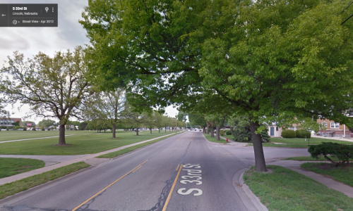
ARTERIALS
I avoid bigger streets when possible, but sometimes to connect my residential-street routes, I have to take a brief jaunt down a smaller arterial – think 33rd Street, not 27th Street. When I look for rideable arterials, the key for me is having an escape route for drivers to pass me. This could either be a center turn lane or another lane of traffic going in the same direction.
If you are not comfortable riding on main streets, you may opt to take the sidewalk along them. This is legal in most of Lincoln, with the exception of downtown and other business districts. (Details: Lincoln Municipal Code, sec 10.48.170). Do keep in mind that sidewalk riding has its own set of hazards.
Pros
- They’re direct.
Cons
- You’re riding with vehicle traffic. Most drivers are courteous, but some have different ideas of what a 3-foot-minimum pass looks like. (Hint for drivers: Just change lanes.)
SIDEWALKS
You might be surprised that sidewalks are so far down on my list. Like many others, I used to assume that sidewalks are the safest place for cyclists, and I rode them. But it wasn’t long before I realized that sidewalk riding has its own special set of risks stemming from the fact that a cyclist is using a sidewalk at a faster speed than sidewalks are designed for. Approaching someone head-on on a standard-width sidewalk is a game of chicken; approaching someone from behind is near impossible to do courteously, no matter how slow you are going. Drivers backing out of driveways aren’t looking for fast-moving traffic on sidewalks. Drivers pulling up to intersections don’t expect a bicyclist on a sidewalk, either, and they aren’t looking for fast traffic there. Every time you come to a cross street or driveway, you must exercise extreme caution. If it sounds like I’m suggesting that you won’t be riding any faster than walking speed on a sidewalk – I am.
(But Sarah! you might say. Aren’t many bike trails that run alongside streets just giant sidewalks? Yes, basically, they are. Their width eases the problems with passing, but all of the risks from vehicles crossing the trail/sidewalk still apply. The sight lines are usually better for drivers with trails, though, and the trails are usually marked with signs alerting drivers of their presence.)
Pros:
- They’re direct.
- They feel like they’re separated from traffic.
Cons:
- …but they’re not. Vehicles will cross sidewalks at every driveway and intersection, and will not be looking for you there.
- You’ll feel like a menace to pedestrians.
BIG ROADS
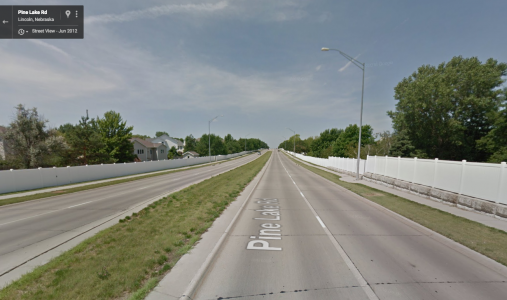
What I’m calling a “big road,” for lack of knowing a more technical term, has houses and businesses and some accommodations for people (sidewalks, maybe even trails) but still feels like a highway. It’s designed with one main purpose in mind: to move motor vehicles quickly. Speed limits are high, usually 45+, and in newer parts of town, you’ll find them lined with backyards and miles of fences, with an occasional strip mall or big-box store for variety. Humans are interlopers on these roads, and I’ve never felt comfortable on them – not on the sidewalk, and especially not on the road.
You’ll find these in parts of town that also have labyrinthine residential streets full of circles and drives and cul-de-sacs, and if you don’t know the area, they can be tough to navigate. The big road is usually the most direct route, and so I have found myself making a brief trip down a sidewalk when I got lost in the neighborhood. In one such trip this weekend, I dodged road debris and broken glass, found the entire sidewalk blocked by a digital construction message board, and saw cracks so big that plastic cups were lodged down in them. It was doable, but not pleasant.
Pros:
- They’re direct, and easy to use for navigation.
Cons:
- Riding on sidewalks is unpleasant.
- Riding on the road is harrowing for even the most experienced riders.
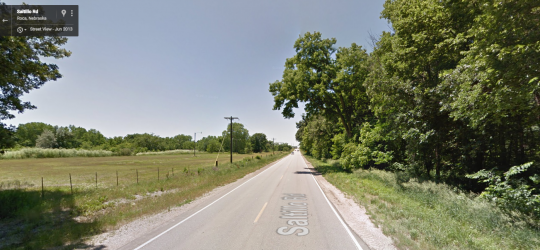
QUASI-HIGHWAY
I’m using “quasi-highway” as a catch-all for any high-traffic roads without any facilities for walking or biking, and not even a shoulder – think Saltillo Road here. I doubt I’m the only one for whom roads like Saltillo are the last place we’d want to ride, so the fact that cyclists do still take them demonstrates that the bike route options in those parts of town are sorely lacking. If you do, take every precaution you can: wear your helmet, wear bright clothing, use lights (even in the day), and just hope no one in a vehicle is playing Pokémon Go at the wheel.
Pros:
- You’ll rarely need to stop – as in highway riding, intersections are at a minimum.
Cons:
- Drivers are going fast, and they do not want to slow, stop, or pass. Many drivers on these roads are aware that cyclists use the routes, and are downright hostile toward riders.
RESOURCES FOR PLANNING YOUR ROUTE
- A great starting point for route planning is the Lincoln trails map produced by Great Plains Trails Network, which shows both trails and on-street bike routes. Check it out online or pick one up at your local bike shop.
- Google Maps‘ satellite view is a great way to see which type/size of roads you’re dealing with. Their bike directions aren’t half bad, either.
- You may want to use a service like MapMyRide (note: account required) to draw out a route and get estimated distance, time, etc. – and you can send your route to your phone or print it.
Well thought out article. Thank you!
Great read and very detailed!!! May add that the ‘Strava heat map’ is also a great reference tool to find popular routes used by avid cyclists. Not only in Lincoln is this tool helpful, but also when traveling and looking for a popular route throughout the country.
http://labs.strava.com/heatmap/#6/-102.23877/38.39334/blue/bike